Woodland Tree Inventory Pricing
Urban Forestry Intelligence for Permitting & Development
Defensible, decision-ready tree data to help teams understand regulatory exposure and mitigation drivers.
What Factors Drive the Price Up?
- Site acreage and tree density
- Complex topography or restricted access
- Overnight travel for remote locations
- Municipal code requirements (e.g. evaluating 4” vs 24” trees)
- Extensive reporting requirements (canopy calcs, heritage status, etc.)
- Correcting inaccurate surveyor data (DBH errors, clump trees, etc.)
What Factors Drive the Price Down?
- Smaller plots or minimal tree cover
- Accurate GPS tree locations provided
- No custom reporting or internal justification tools
- Choosing Tier 1 or Tier 2 without add-ons
- Flat, accessible terrain
Why Are Some Companies So Expensive?
- Subcontracting fieldwork with markup
- Using premium equipment or complex analytics
- Including broader scopes not needed for permitting
Why Are Some Companies So Cheap?
- Uncertified staff or students with minimal field experience
- Lack of GNSS/GPS precision
- “Gut-based” condition ratings without a defensible method
- Tree service firms using inventories as lead gen for removals
- No understanding of municipal code requirements
Where Do Your Prices Fall?
$2,800–$7,200 for small or moderate sites
$9,000–$25,000+ for large, dense, or complex sites
$1,200 minimum for any project
| Tier | Best For | Key Inclusions | Outcome |
|---|---|---|---|
| Tier 1 Permitting Ready |
Final-stage submittals | Arborist report + CAD-ready map | Defensible permit-ready deliverables |
| Tier 2 Decision & Mitigation Clarity (Most Selected) |
Pre-design planning | Everything in Tier 1 + mitigation snapshot + strategy tools | Fewer redesigns and mitigation surprises |
| Tier 3 Risk & Permitting Support |
High-risk reviews | Everything in Tier 2 + municipal response support | Continuity through permit review cycles |
Most teams select Tier 2 because it gives them early visibility into which trees actually matter before design and permitting decisions are locked in.
What Does a $3,700 vs. $17,800 Tree Inventory Actually Look Like?
Pricing doesn’t just depend on acreage—it’s driven by tree density, regulatory complexity, and how early your team needs clarity.
Below are two real-world examples to show what different price points, deliverables, and project types look like in practice.
|
|
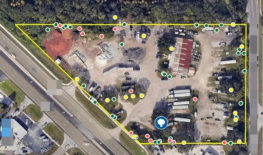
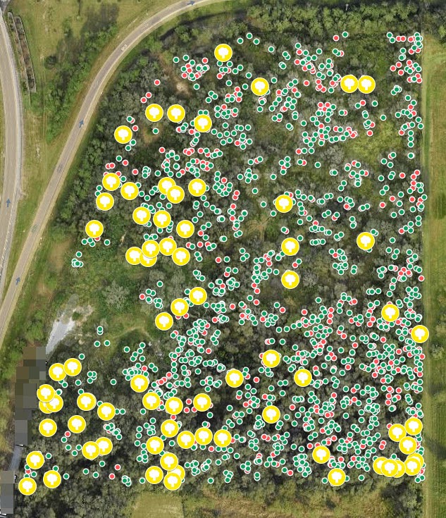
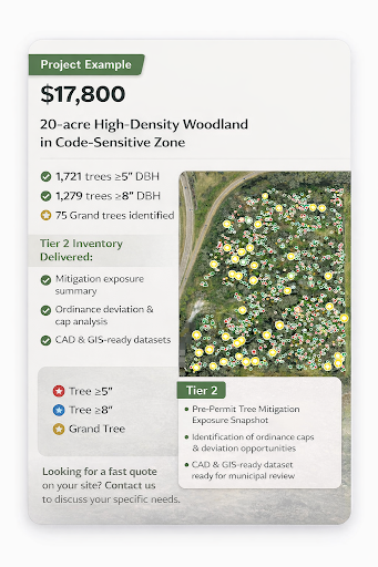
| Project 1 – Lower Price Point | Project 2 – Higher Price Point |
| $3,700 | $17,800 |
| 5.21 acres, lightly treed, few mitigation triggers, 1 Grand tree | 20 acres, densely wooded, 75 grand trees |
| Tier 2, moderately strict jurisdiction | Tier 2, code-sensitive zone |
Both projects selected Tier 2 because early mitigation clarity saved time and reduced downstream permitting risk.
What’s driving your project cost? We can help you scope that in a single call.
Most teams think it’s about acreage—but there are four hidden risk drivers that will make or break your budget and schedule. This quick explainer breaks it down.
Content created by TreeCheckUp, powered by Notebook LM.
Get a Custom Quote for Your Site
Not sure what tier you need or how complex your site might be? We can give you a pricing range in one call—or faster if you upload your site plan.
- ⚡ Response in 24 hours
- 📍 Based on acreage, tree density, and jurisdiction
- 🧾 Includes a recommended service tier and price range
Paying more upfront for accuracy and defensibility saves exponentially more in:
- Redesigns from surprise tree impacts
- Delays from clarification requests
- Over-mitigation due to misclassified trees
We’ve seen a gradual increase in cost only for projects requiring:
- More complex mitigation forecasts
- Redundant site visits due to inaccurate surveys
- Escalated municipal scrutiny
We do not offer financing, but phased-scope options (e.g., starting with Tier 1) may be available depending on urgency and site readiness.
Here’s a real example of a 20-acre site in a code-sensitive zone.
This high-density woodland included over 1,700 trees, and required deep mitigation insight to avoid unnecessary redesigns.
The client selected Tier 2 to gain clarity before finalizing their site plan.
No surprise fees—but additional charges may apply if:
- Surveyor data is incomplete or incorrect
- Multiple site visits are required
- Reporting scope changes after fieldwork
Get a Custom Quote for Your Site
Not sure what tier you need or how complex your site might be? We can give you a pricing range in one call—or faster if you upload your site plan.
- ⚡ Response in 24 hours
- 📍 Based on acreage, tree density, and jurisdiction
- 🧾 Includes a recommended service tier and price range
Mitigation is often influenced by tree condition, species classification, and regulatory exemptions—factors that are not evaluated in survey-only data. When an arborist assesses tree health and regulatory status, some trees may qualify for exemption, reduced mitigation, or different treatment under local code, which can change mitigation calculations.
Often, yes. Survey data provides a starting point, but an arborist inventory translates that data into permitting-ready information. Many projects use existing survey tree locations and then engage an arborist to verify accuracy, evaluate condition, and assess regulatory implications before permit submittal.
An arborist-led inventory involves professional evaluation, regulatory interpretation, and documentation aligned with municipal criteria. The cost reflects the level of analysis, expertise, and permitting support provided—not just field measurements. This additional work often reduces downstream redesigns, review comments, and mitigation surprises.
Not always. For projects that only require tree locations for reference, survey-based data may be sufficient. However, when tree information is used for permitting, mitigation, or preservation decisions, an arborist inventory is typically required or strongly recommended.
No. Final permitting decisions are made by the reviewing authority. An arborist-led inventory helps ensure that tree data is complete, defensible, and aligned with adopted criteria, which can reduce uncertainty and follow-up questions during review, but it does not guarantee approval.
Pricing isn’t just about how many acres you have—it’s about what’s on those acres, how your municipality defines protection thresholds, and how early you want to know which trees will actually drive your permitting risk.
The charts below show what affects your price, how cost scales with tree count, and what’s included at each service tier.
🔧 Top 5 Price Drivers
These five factors consistently have the biggest impact on your inventory cost.
🌲 Cost by Tree Count
Here’s how price typically scales as the number of trees increases on a site.
🧩 Tier Comparison Cheat Sheet
Not sure which tier is right for you? This breakdown shows what’s included at each level.
| Tier | Tree Location & Condition |
Permit-Ready Report |
Mitigation Exposure Snapshot |
Ordinance Strategy Guidance |
Municipal Review Support |
|---|---|---|---|---|---|
| Tier 1 | ✓ | ✓ | |||
| Tier 2 | ✓ | ✓ | ✓ | ✓ | |
| Tier 3 | ✓ | ✓ | ✓ | ✓ | ✓ |
Still not sure where your project falls?
👉 Contact us for a quick scoping call
👉 Or upload your site survey and we’ll give you a range the same day
A Woodland Tree Inventory is not just data—it’s a strategic permit risk reduction tool.
It’s fair to ask: Is this extra cost really necessary?
Here’s what we’ve seen—again and again—from teams that try to cut corners with tree data:
Cheap Tree Surveys Come With Expensive Consequences:
⚠️ Missed Grand or Heritage Trees
Discovery late in design = layout changes, resubmittals, delays
⚠️ Bad DBH or Species Data
Inflated mitigation fees, over-preservation, inaccurate canopy calcs
⚠️ Survey-Only = No Regulatory Insight
Code triggers missed → reviewer comments → avoidable revisions
⚠️ Multiple Site Visits
When GPS isn’t accurate or trees weren’t rated on-site, you pay for field time twice
A Woodland Tree Inventory Pays Off When:
✅ You want to reduce permitting risk
✅ You want to avoid unnecessary mitigation
✅ You want defensible condition ratings tied to code
✅ You want to make faster design decisions based on real constraints
✅ The cost of doing it right is a fraction of the cost of doing it over.
🧩 What You're Really Buying:
Clarity → Speed → Fewer Surprises
A Woodland Tree Inventory isn’t just data—it’s a strategy layer that lets your team move forward confidently, before permit submittal.
Serving Clearwater, Largo, Dunedin, Palm Harbour, Tarpon Springs, East Lake, New Port Richey, Port Richey, Citrus Springs, Homosassa, Homosassa Springs, Inverness, Brooksville, Spring Hill, Wesley Chapel, Zephyrhills, Hudson, Citrus Park, Lutz, Sugarmill Woods, Ocala, Crystal River and more.